
Using a Trail Ridge Road Colorado map before your drive makes the trip much easier especially for first-time visitors. The route crosses Rocky Mountain National Park and includes multiple overlooks, pullouts, hiking trails, and visitor centers.
Download an offline park map before entering because mobile service disappears in several mountain sections. Google Maps works in some areas but offline navigation helps avoid confusion during the drive.
The National Park Service also provides updated maps showing parking areas, scenic overlooks on Trail Ridge Road, road conditions, and seasonal closures. These maps help travelers plan realistic stop times instead of rushing through the scenic drive.
Is Trail Ridge Road in Colorado Open?
One of the most searched questions every year is “Is Trail Ridge Road in Colorado open?” The answer depends heavily on snowfall and weather conditions in Rocky Mountain National Park.
The road usually opens around late May or early June after snowplow crews clear deep snow from higher elevations. Strong winter storms can delay opening dates because some snow drifts reach several feet high.
Travelers should always check the official Trail Ridge Road opening schedule before visiting. Sudden snowstorms and icy conditions can temporarily close sections even during summer months.
Trail Ridge Road Colorado Opening Date 2026
The official Trail Ridge Road Colorado opening date 2026 has not been confirmed yet because annual weather patterns affect snow removal operations. In most years the road fully opens between late May and mid-June.
Spring weather in the Rockies changes quickly which makes exact predictions difficult. Heavy snow seasons sometimes delay access to higher elevations for several extra weeks.
If you plan a summer trip book flexible travel dates whenever possible. Checking official park updates a few days before arrival helps avoid surprises.
Trail Ridge Road Colorado Closure Dates 2026
Most seasonal closures begin sometime in October when snow and ice return to the mountains. Exact Trail Ridge Road Colorado closure dates 2026 will depend on fall weather conditions and early winter storms.
Some years bring heavy snowfall earlier than expected while other seasons stay mild into late autumn. Temporary closures also happen during storms for safety reasons.
September often provides the safest balance between good weather, smaller crowds, and beautiful Trail Ridge Road fall colors throughout the park.
How High Is Trail Ridge Road in Colorado?
Many travelers wonder how high is Trail Ridge Road in Colorado before planning the drive. The highest point reaches approximately 12,183 feet above sea level near Fall River Pass.
That elevation makes it one of the highest paved roads in North America. Visitors coming from lower elevations sometimes feel dizzy, tired, or short of breath after reaching alpine areas.
These Trail Ridge Road Colorado elevation changes happen quickly during the drive. Drink extra water and move slowly during short hikes to avoid altitude sickness symptoms.
Trail Ridge Road Colorado Weather and Road Conditions
Trail Ridge Road Colorado weather changes rapidly because of the high elevation. Sunny skies can suddenly turn into cold rain, fog, or snow within a short time.
Summer afternoons often bring stronger winds and occasional thunderstorms near alpine sections. Morning hours usually offer calmer driving conditions and clearer mountain views.
Checking Trail Ridge Road road conditions before leaving your hotel can save time and stress. Weather updates become especially important during spring and fall when temperatures shift quickly.
Trail Ridge Road Colorado Web Cam and Live Conditions
Checking a Trail Ridge Road Colorado web cam before your drive helps you see current visibility, snow coverage, and traffic conditions in real time.
Live webcams near Alpine Visitor Center and other mountain areas give travelers a realistic idea of weather conditions before entering the park. This becomes extremely helpful during changing seasons.
Many experienced travelers check webcam updates early in the morning before starting the Estes Park to Trail Ridge Road drive.
Best Time for Trail Ridge Road Fall Colors
Trail Ridge Road fall colors usually peak between mid-September and early October depending on weather patterns and elevation changes.
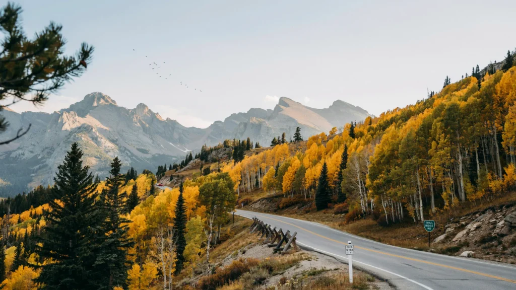
Golden aspens create some of the most beautiful scenery in Colorado during this period. Morning sunlight makes the yellow trees glow against dark mountain landscapes.
The western side near Grand Lake often provides excellent photography opportunities for travelers searching for classic Colorado mountain drive aesthetic views.
Must read: Best time to visit Rocky Mountain National Park.
Can You Drive Trail Ridge Road in One Day?
Yes you can drive Trail Ridge Road in one day but rushing through the route reduces the experience. Most visitors need at least 5 to 7 hours to enjoy the viewpoints, short hikes, wildlife stops, and scenic overlooks.
Travelers who enjoy photography or hiking often spend an entire day exploring the area. Some people even split the experience across two days to avoid feeling rushed.
If you are planning a Colorado mountain road trip itinerary this scenic drive deserves extra time.
Cycling Trail Ridge Road Colorado
Cycling Trail Ridge Road Colorado has become popular among experienced cyclists looking for a challenging mountain climb and unforgettable alpine scenery.
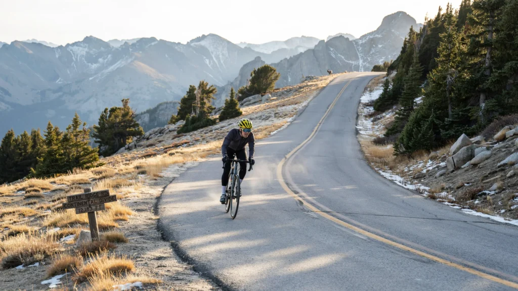
The steep elevation gain and thin mountain air make this ride physically demanding. Strong winds and changing weather conditions also create extra challenges for cyclists.
Many riders begin early in the morning to avoid afternoon traffic and stronger winds near the highest sections of the road.
Trail Ridge Road Colorado Tips for First-Time Visitors
Trail Ridge Road Colorado for first-time visitors feels exciting but preparation matters. Arriving early helps avoid traffic while giving you better wildlife viewing opportunities.
Bring layers because temperatures change quickly at higher elevations. Even during warm summer afternoons the alpine tundra can feel cold and windy.
These simple Trail Ridge Road Colorado travel tips improve comfort and help travelers enjoy the scenic drive without unnecessary stress.
Best Photography Spots on Trail Ridge Road
Trail Ridge Road photography spots appear almost everywhere along the route but a few locations stand out for best mountain towns near Denver.
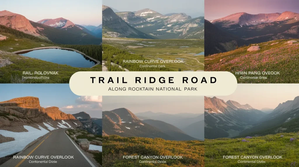
Forest Canyon Overlook provides deep canyon scenery while Rainbow Curve offers wide panoramic landscapes across Rocky Mountain National Park. Milner Pass works well for iconic Continental Divide photos.
Sunrise and sunset create the best lighting conditions for photographers. Early morning also helps avoid crowded parking areas at popular overlooks.
Is Trail Ridge Road Worth It?
Many travelers ask “Is Trail Ridge Road worth it?” after seeing long drive times and changing weather forecasts. The answer for most visitors is absolutely yes.
This Rocky Mountain National Park scenic drive combines alpine tundra, wildlife sightings, dramatic overlooks, and mountain landscapes into one unforgettable experience.
Even travelers with limited hiking experience can enjoy incredible views because many of the best stops sit close to parking areas.
Is Trail Ridge Road in Colorado open year round?
No. The road closes seasonally because of snow and harsh winter weather.
How long does it take to drive Trail Ridge Road?
Most visitors spend 5 to 7 hours including scenic stops and short hikes.
What is the highest point on Trail Ridge Road?
The highest point reaches about 12,183 feet above sea level.
Can you drive Trail Ridge Road in one day?
Yes. Most travelers complete the scenic drive in one full day.
What are the best stops on Trail Ridge Road Colorado?
Top stops include Many Parks Curve, Alpine Visitor Center, Forest Canyon Overlook, and Milner Pass.
What is the best time to visit Trail Ridge Road Colorado?
July through September offers the best weather and road conditions.